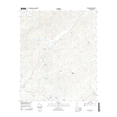
2014 Map of Wadley North
USGS Topo · Published 2014About this map
The Tallapoosa River defines the landscape of Randolph County as it winds southward toward Wadley, serving as the central topographical axis for this region. The settlement pattern is characterized by small rural communities and numerous family or community burial sites, including Pleasant Grove Cem, Knight Cem, and Antioch Cem. Educational and religious foundations are prominent, anchored by the Southern Union State Community College in the south and the Forester Chapel further north. Historical river crossings and landforms like Hodge Island and Price Island suggest the long-standing importance of the river corridor for local transport and resource access. The surrounding terrain is marked by distinctive rises such as Oak Mtn and Swan Hill, while smaller hamlets like Malone, Corinth, and Louina are connected by a network of county roads that follow the ridges and valleys of the local tributaries.
Find a feature on this map
78 named features on this map. Tap any name to fly to it.
Don’t see what you’re looking for? This feature index may not catch every label — zoom into the map to look around manually.
Map Details
Editions of this 2014 Wadley North Map
This is the sole edition of this map. No revisions or reprints were ever made.
Other maps of this area

1891 · Ashland
USGS Topo · 1:125,000

1899 · Wedowee
USGS Topo · 1:125,000

1902 · Wedowee
USGS Topo · 1:125,000

1953 · Atlanta
USGS Topo · 1:250,000

1957 · Atlanta
USGS Topo · 1:250,000

1958 · Atlanta
USGS Topo · 1:250,000

1969 · Wadley North
USGS Topo · 1:24,000
1969 · Wedowee
USGS Topo · 1:24,000
1969 · Daviston
USGS Topo · 1:24,000
1969 · Wadley South
USGS Topo · 1:24,000