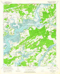
1960 Map of Wadmalaw Island
USGS Topo · Published 1964About this map
The tidal landscape of the South Carolina Lowcountry is defined here by the intricate branching of the Wadmalaw River and Bohicket Creek as they wind around Wadmalaw Island and Johns Island. In the early 1960s, this region maintained a largely rural character centered on water-bound commerce and transit via the Intracoastal Waterway. The presence of numerous small community centers like Wadmalaw Island Po and Oakgrove suggests a network of family farms and local gatherings. Significant educational and religious landmarks are scattered throughout the islands, including the Promised Land Sch and Jerusalem Ch. Along the northern edge, the Seaboard Atlantic Coast Line railroad and the Maybank Highway provided critical terrestrial links to the mainland for towns like Hollywood and Meggett, while coastal landings and sound-side points like Martins Point emphasize the area's continued reliance on the surrounding waters.
Find a feature on this map
44 named features on this map. Tap any name to fly to it.
Don’t see what you’re looking for? This feature index may not catch every label — zoom into the map to look around manually.
Map Details
Editions of this 1960 Wadmalaw Island Map
2 editions found
Other maps of this area

1918 · Kiawah Island
USGS Topo · 1:21,120

1918 · Cottageville
USGS Topo · 1:62,500

1919 · Johns Island
USGS Topo · 1:21,120

1919 · Edisto Island
USGS Topo · 1:62,500

1919 · Wadmelaw Island
USGS Topo · 1:62,500

1919 · Legareville
USGS Topo · 1:21,120

1920 · Ravenels
USGS Topo · 1:62,500

1943 · Cottageville
USGS Topo · 1:62,500

1943 · Legareville
USGS Topo · 1:24,000

1943 · Edisto Island
USGS Topo · 1:62,500