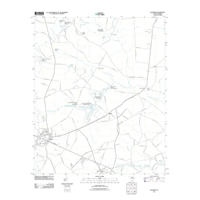
2011 Map of Wagener
USGS Topo · Published 2011About this map
Wagener serves as the central hub of this landscape, where a dense network of local roads converges at the intersection of State Highway 113 and Highway 302. The region is defined by the winding course of the North Fork Edisto River and its numerous tributaries, including Black Creek and Giddy Swamp Creek. A series of water management features and mill ponds, such as Edisto Lake and Amelia Lake, reflect a long history of utilizing the local hydrology. The rural character is punctuated by smaller settlements like Berlin and Perry, along with more remote points like Thor.
Find a feature on this map
120 named features on this map. Tap any name to fly to it.
Don’t see what you’re looking for? This feature index may not catch every label — zoom into the map to look around manually.
Map Details
Editions of this 2011 Wagener Map
This is the sole edition of this map. No revisions or reprints were ever made.
Other maps of this area

1944 · Gilbert
USGS Topo · 1:62,500

1944 · Seivern
USGS Topo · 1:62,500

1944 · Edmund
USGS Topo · 1:62,500

1946 · Woodford
USGS Topo · 1:62,500

1954 · Augusta
USGS Topo · 1:250,000

1957 · Augusta
USGS Topo · 1:250,000

1958 · Augusta
USGS Topo · 1:250,000

1961 · Augusta
USGS Topo · 1:250,000

1962 · Augusta
USGS Topo · 1:250,000
1972 · Pelion East
USGS Topo · 1:24,000