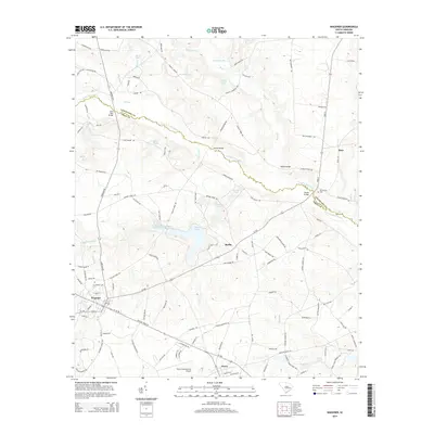
2014 Map of Wagener
USGS Topo · Published 2014About this map
The N Fork Edisto River carves a winding path along the boundary between Lexington and Aiken counties, anchoring a landscape defined by its blackwater tributaries and numerous millponds. The town of Wagener stands as a central hub, connected to the smaller settlements of Perry and Berlin by a network of state routes like SC-302 and SC-39. This area of the South Carolina Midlands maintains a distinct rural character, where large water bodies such as Edisto Lake, Amelia Lake, and Collums Millpond reveal the legacy of historical water management and milling along Giddy Swamp Cr. Local infrastructure is marked by several river crossings, including Rambo Bridge and Horses Bridge, while Perry International Airport provides an unexpected aviation footprint in the southern portion of the sheet. For those tracing family history, the Mt Herman Cem serves as a significant genealogical marker near the river’s edge.
Find a feature on this map
133 named features on this map. Tap any name to fly to it.
Don’t see what you’re looking for? This feature index may not catch every label — zoom into the map to look around manually.
Map Details
Editions of this 2014 Wagener Map
This is the sole edition of this map. No revisions or reprints were ever made.
Other maps of this area

1944 · Gilbert
USGS Topo · 1:62,500

1944 · Seivern
USGS Topo · 1:62,500

1944 · Edmund
USGS Topo · 1:62,500

1946 · Woodford
USGS Topo · 1:62,500

1954 · Augusta
USGS Topo · 1:250,000

1957 · Augusta
USGS Topo · 1:250,000

1958 · Augusta
USGS Topo · 1:250,000

1961 · Augusta
USGS Topo · 1:250,000

1962 · Augusta
USGS Topo · 1:250,000
1972 · Pelion East
USGS Topo · 1:24,000