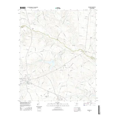
2017 Map of Wagener
USGS Topo · Published 2017About this map
The N Fork Edisto River meanders across this landscape on the border of Lexington and Aiken counties, anchoring a network of creeks and man-made impoundments. The town of Wagener serves as a local hub in the southwest, while the smaller settlements of Berlin, Perry, and Thor are distributed along a web of county roads and historic river crossings like Greens Bridge and Rambo Bridge. This era of the region’s development is characterized by numerous small bodies of water and dams, including Collums Mill Pond Dam and Edisto Lake, which highlight the importance of water management in this rural corridor. Near the eastern edge, the Mount Herman Cem provides a point of interest for genealogists tracing local families, while the Perry International Airport indicates the modern infrastructure serving these traditional communities.
Find a feature on this map
106 named features on this map. Tap any name to fly to it.
Don’t see what you’re looking for? This feature index may not catch every label — zoom into the map to look around manually.
Map Details
Editions of this 2017 Wagener Map
This is the sole edition of this map. No revisions or reprints were ever made.
Other maps of this area

1944 · Gilbert
USGS Topo · 1:62,500

1944 · Seivern
USGS Topo · 1:62,500

1944 · Edmund
USGS Topo · 1:62,500

1946 · Woodford
USGS Topo · 1:62,500

1954 · Augusta
USGS Topo · 1:250,000

1957 · Augusta
USGS Topo · 1:250,000

1958 · Augusta
USGS Topo · 1:250,000

1961 · Augusta
USGS Topo · 1:250,000

1962 · Augusta
USGS Topo · 1:250,000
1972 · Pelion East
USGS Topo · 1:24,000