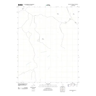
2011 Map of Wagon Box Mesa
USGS Topo · Published 2011About this map
Wagon Box Mesa stands as a central topographic feature in this arid section of Garfield County, where the high desert is defined by a network of seasonal watercourses and deeply incised canyons. The landscape is navigated via the Burr Trl and the Capitol Reef National Park Rd, which provide access through the complex drainage systems of Moody Creek and the North Fork Silver Falls Creek. Prominent landmarks such as Peak-a-boo Rock and the Studhorse Peaks rise above the surrounding terrain, serving as essential visual waypoints. The northeastern corner of the map shows the transition into Swap Canyon and Burr Canyon, following the path of Halls Creek. This 2011 survey documents the established backcountry routes and hydrological features of this remote Utah territory, mapping the precise course of canyons and washes that dictate movement through the region.
Find a feature on this map
13 named features on this map. Tap any name to fly to it.
Don’t see what you’re looking for? This feature index may not catch every label — zoom into the map to look around manually.
Map Details
Editions of this 2011 Wagon Box Mesa Map
This is the sole edition of this map. No revisions or reprints were ever made.
Other maps of this area

1886 · Escalante
USGS Topo · 1:250,000

1886 · Henry Mountains
USGS Topo · 1:250,000

1892 · Henry Mountains
USGS Topo · 1:250,000

1953 · Mt Pennell
USGS Topo · 1:62,500

1953 · Circle Cliffs 1 SE
USGS Topo · 1:24,000

1953 · Circle Cliffs 4 NW
USGS Topo · 1:24,000

1953 · Circle Cliffs 1 SW
USGS Topo · 1:24,000

1953 · Mt Pennell 3 NW
USGS Topo · 1:24,000
1953 · Circle Cliffs 1 NW
USGS Topo · 1:24,000
1953 · Circle Cliffs 1 NE
USGS Topo · 1:24,000