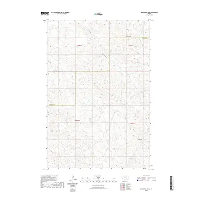
2020 Map of Wagon Box Spring
USGS Topo · Published 2020About this map
Bull Mountain Rd provides the primary transit route through this high-country landscape on the border of Yellowstone and Big Horn Counties. The terrain is defined by a series of drainages and topographical features, including Rough Coulee and the prominent Pine Ridge. Water sources are critical markers in this environment, with Wagon Box Spring situated near the head of Sand Creek. The map details the intricate branching of local waterways such as Lost Boy Creek, Chimney Creek, and Kaiser Creek, which carve through the land across multiple townships and ranges. This 2020 survey documents the modern state of the public land survey system, illustrating the precise boundaries of t3n r31e, t3n r32e, t2n r31e, and t2n r32e.
Find a feature on this map
15 named features on this map. Tap any name to fly to it.
Don’t see what you’re looking for? This feature index may not catch every label — zoom into the map to look around manually.
Map Details
Editions of this 2020 Wagon Box Spring Map
This is the sole edition of this map. No revisions or reprints were ever made.
Other maps of this area

1894 · Fort Custer
USGS Topo · 1:125,000

1954 · Hardin
USGS Topo · 1:250,000

1954 · Forsyth
USGS Topo · 1:250,000

1957 · Hardin
USGS Topo · 1:250,000

1957 · Forsyth
USGS Topo · 1:250,000

1958 · Forsyth
USGS Topo · 1:250,000

1958 · Hardin
USGS Topo · 1:250,000

1960 · Chimney Creek
USGS Topo · 1:24,000
1960 · Lemon Ranch
USGS Topo · 1:24,000

1960 · Waco
USGS Topo · 1:24,000