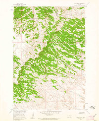
1960 Map of Lemon Ranch
USGS Topo · Published 1962About this map
Lemon Ranch sits at the heart of a dissected landscape where the Yellowstone and Big Horn county line divides the high country. The terrain is dominated by the prominent spine of Pine Ridge, which dictates the drainage patterns of the surrounding territory. A complex network of ravines and seasonal watercourses, including Wagon Box Coulee, Robs Coulee, and Deadmans Coulee, carves through the timbered ridges, illustrating the era's reliance on established pathways like the Sorrel Horse Trail.
Find a feature on this map
15 named features on this map. Tap any name to fly to it.
Don’t see what you’re looking for? This feature index may not catch every label — zoom into the map to look around manually.
Map Details
Editions of this 1960 Lemon Ranch Map
2 editions found
Other maps of this area

1894 · Fort Custer
USGS Topo · 1:125,000

1954 · Hardin
USGS Topo · 1:250,000

1954 · Forsyth
USGS Topo · 1:250,000

1957 · Hardin
USGS Topo · 1:250,000

1957 · Forsyth
USGS Topo · 1:250,000

1958 · Forsyth
USGS Topo · 1:250,000

1958 · Hardin
USGS Topo · 1:250,000

1960 · Foster
USGS Topo · 1:24,000

1960 · Ninemile Point
USGS Topo · 1:24,000

1960 · Chimney Creek
USGS Topo · 1:24,000