
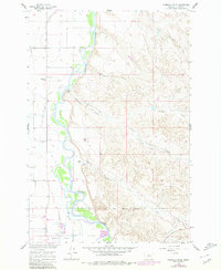
1960 Map of Ninemile Point
USGS Topo · Published 1962About this map
The Bighorn River carves a winding path through this Montana landscape, where 1960s agricultural development is visible through an intricate network of irrigation projects. The Quincy and Chicago Burlington and Low Horn Big Canal and Farmers Canal demonstrate the intensive effort to manage water in the river valley. Along the Chicago Burlington and Quincy railroad line, industrial activity is centered near Whitman, notably featuring a Sugar Refinery and its associated Stack.
Find a feature on this map
27 named features on this map. Tap any name to fly to it.
Don’t see what you’re looking for? This feature index may not catch every label — zoom into the map to look around manually.
Map Details
Editions of this 1960 Ninemile Point Map
2 editions found
Other maps of this area

1894 · Fort Custer
USGS Topo · 1:125,000

1954 · Hardin
USGS Topo · 1:250,000

1957 · Hardin
USGS Topo · 1:250,000

1958 · Hardin
USGS Topo · 1:250,000

1960 · Foster
USGS Topo · 1:24,000

1960 · Chimney Creek
USGS Topo · 1:24,000

1960 · Walker Hill
USGS Topo · 1:24,000

1960 · Hardin
USGS Topo · 1:24,000
1960 · Lemon Ranch
USGS Topo · 1:24,000
1967 · Little Dry Creek
USGS Topo · 1:24,000