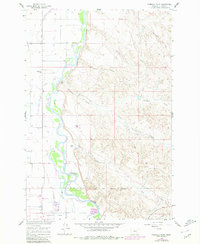
1960 Map of Ninemile Point
USGS Topo · Published 1980About this map
The Bighorn River carves a deep valley through this Big Horn County landscape, punctuated by the sharp bend at Ninemile Point. This 1960s survey reveals a landscape defined by irrigation and infrastructure, where the Big Horn Low Line Canal, Two Leggins Canal, and Farmers Canal trace the contours of the river valley to support local agriculture. The transition from early rail era to mid-century industrialization is evident in the presence of an Old RR Grade alongside the modern Sugar Refinery near Whitman. Local life centers on the river bottom and adjacent coulees, with established holdings like the Miller Ranch and Ottun Ranch situated near Ninemile Creek. Educational and recreational history is marked by the Nine Mile Sch and the Ft Custer Country Club to the south, while the northern edge touches the Crow Indian Reservation Boundary.
Find a feature on this map
29 named features on this map. Tap any name to fly to it.
Don’t see what you’re looking for? This feature index may not catch every label — zoom into the map to look around manually.
Map Details
Editions of this 1960 Ninemile Point Map
2 editions found
Other maps of this area

1894 · Fort Custer
USGS Topo · 1:125,000

1954 · Hardin
USGS Topo · 1:250,000

1957 · Hardin
USGS Topo · 1:250,000

1958 · Hardin
USGS Topo · 1:250,000

1960 · Foster
USGS Topo · 1:24,000

1960 · Ninemile Point
USGS Topo · 1:24,000

1960 · Chimney Creek
USGS Topo · 1:24,000

1960 · Walker Hill
USGS Topo · 1:24,000

1960 · Hardin
USGS Topo · 1:24,000
1960 · Lemon Ranch
USGS Topo · 1:24,000