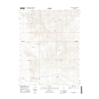
2017 Map of Wah Wah Summit
USGS Topo · Published 2017About this map
The Wah Wah Mountains dominate this high-desert landscape along the boundary of Millard and Beaver Counties. This modern survey illustrates the complex natural drainage patterns of the Great Basin, where features like Lawson Cove Canyon and Pierce Canyon carve through the steep terrain. The southern portion of the map is centered on Wah Wah Summit, a critical passage through the range that serves as a transit point across the arid interior. Notable local landmarks like the uniquely named Eye of Needle and Sols Knoll provide specific points of reference for those navigating the basin-and-range topography. The map also documents the transition from the high ridges down to lower elevations at Pierson Cove and Wah Wah Cove, reflecting the remote and undeveloped character of this part of western Utah.
Find a feature on this map
17 named features on this map. Tap any name to fly to it.
Don’t see what you’re looking for? This feature index may not catch every label — zoom into the map to look around manually.
Map Details
Editions of this 2017 Wah Wah Summit Map
This is the sole edition of this map. No revisions or reprints were ever made.
Other maps of this area

1953 · Richfield
USGS Topo · 1:250,000

1958 · Richfield
USGS Topo · 1:250,000

1959 · Frisco
USGS Topo · 1:62,500

1960 · Frisco Peak
USGS Topo · 1:62,500

1960 · Wah Wah Summit
USGS Topo · 1:62,500

1971 · Sewing Machine Pass
USGS Topo · 1:24,000

1971 · Lamerdorf Peak NW
USGS Topo · 1:24,000

1980 · Wah Wah Mts. South
USGS Topo · 1:100,000

1980 · Wah Wah Mts. North
USGS Topo · 1:100,000
1989 · Wah Wah Cove
USGS Topo · 1:24,000