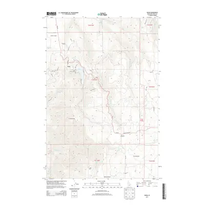
2013 Map of Waha
USGS Topo · Published 2013About this map
Waha sits at the heart of this high-plateau landscape, where the terrain breaks sharply into complex drainages and ridges. The presence of the Sweetwater Hatchery and the Waha Lake Access Area near Lake Waha points to a geography defined by water management and conservation. To the south, Craig Mtn and Ft Simons Ridge overlook a network of seasonal and permanent creeks, including the W Fork Sweetwater Cr and Captain John Cr. This 2013 survey illustrates the modern transition from agriculture to recreation, with labels for the Black Pine Campground and remote meadows like Kruze Meadows and Benton Meadows. The infrastructure of the Webb Cr Canal and local mountain routes like Snow Grade reveal how the local population has navigated and utilized this elevated territory within Nez Perce County.
Find a feature on this map
48 named features on this map. Tap any name to fly to it.
Don’t see what you’re looking for? This feature index may not catch every label — zoom into the map to look around manually.
Map Details
Editions of this 2013 Waha Map
This is the sole edition of this map. No revisions or reprints were ever made.
Other maps of this area

1946 · Limekiln Rapids
USGS Topo · 1:62,500

1955 · Pullman
USGS Topo · 1:250,000

1958 · Pullman
USGS Topo · 1:250,000

1958 · Sweetwater
USGS Topo · 1:24,000

1958 · Lewiston Orchards South
USGS Topo · 1:24,000

1958 · Lewiston Orchards
USGS Topo · 1:62,500

1958 · Culdesac
USGS Topo · 1:62,500

1967 · Hoover Point
USGS Topo · 1:24,000

1968 · Waha
USGS Topo · 1:24,000
1968 · Winchester West
USGS Topo · 1:24,000