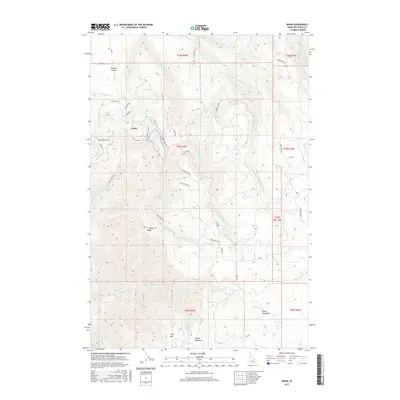
2017 Map of Waha
USGS Topo · Published 2017About this map
Waha serves as the focal point of this high-plateau region, situated near a cluster of mountain waters including Lake Waha, Blue Lake, and Mud Lake. The landscape is defined by its dramatic verticality, as the drainage systems of W Fork Sweetwater Cr and Captain John Cr cut through the terrain toward the surrounding canyons. To the south, the topography rises toward Craig Mtn and the broad highland expanses of Benton Meadows and Kruze Meadows, areas historically significant for summer grazing. The transportation network, comprising routes like Stagecoach Rd and Bald Eagle Dr, follows the ridgelines and contour lines of Ft Simons Ridge. Notable water management is visible via the Webb Cr Canal in the northeast, reflecting the importance of water diversion in this high-altitude Nez Perce County environment. These features reveal a landscape where early settlement and modern land use are dictated by the deep clefts of Tenmile Canyon and the availability of alpine water sources.
Find a feature on this map
44 named features on this map. Tap any name to fly to it.
Don’t see what you’re looking for? This feature index may not catch every label — zoom into the map to look around manually.
Map Details
Editions of this 2017 Waha Map
This is the sole edition of this map. No revisions or reprints were ever made.
Other maps of this area

1946 · Limekiln Rapids
USGS Topo · 1:62,500

1955 · Pullman
USGS Topo · 1:250,000

1958 · Pullman
USGS Topo · 1:250,000

1958 · Sweetwater
USGS Topo · 1:24,000

1958 · Lewiston Orchards South
USGS Topo · 1:24,000

1958 · Lewiston Orchards
USGS Topo · 1:62,500

1958 · Culdesac
USGS Topo · 1:62,500

1967 · Hoover Point
USGS Topo · 1:24,000

1968 · Waha
USGS Topo · 1:24,000
1968 · Winchester West
USGS Topo · 1:24,000