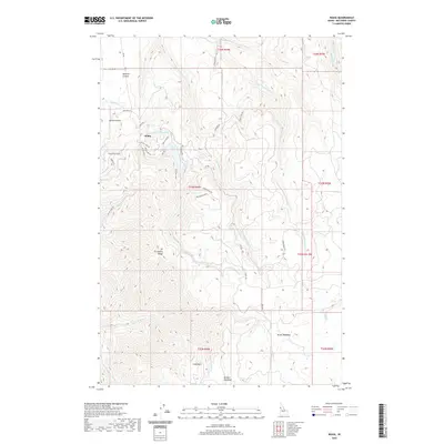
2020 Map of Waha
USGS Topo · Published 2020About this map
Waha sits at the center of this high-elevation plateau in Nez Perce County, where the transition from agricultural land to the steeper drainages of the Snake River breaks is evident. The settlement is defined by its proximity to several high-country water bodies, including Lake Waha, Blue Lake, and Mud Lake. These lakes, along with the Webb Cr Canal, illustrate a landscape managed for water resources amid the varying elevations of Craig Mtn. To the west, the terrain drops sharply into Tenmile Canyon, while to the south, the topographic relief increases around Ft Simons Ridge. The presence of the Red Bird Airport near the northern edge suggests the importance of aerial access to this isolated Idaho upland. Further south, open spaces like Kruze Meadows and Benton Meadows provide contrast to the numerous creek systems, such as Captain John Cr and W Fork Sweetwater Cr, that carve through the surrounding timber and slopes.
Find a feature on this map
44 named features on this map. Tap any name to fly to it.
Don’t see what you’re looking for? This feature index may not catch every label — zoom into the map to look around manually.
Map Details
Editions of this 2020 Waha Map
This is the sole edition of this map. No revisions or reprints were ever made.
Other maps of this area

1946 · Limekiln Rapids
USGS Topo · 1:62,500

1955 · Pullman
USGS Topo · 1:250,000

1958 · Pullman
USGS Topo · 1:250,000

1958 · Sweetwater
USGS Topo · 1:24,000

1958 · Lewiston Orchards South
USGS Topo · 1:24,000

1958 · Lewiston Orchards
USGS Topo · 1:62,500

1958 · Culdesac
USGS Topo · 1:62,500

1967 · Hoover Point
USGS Topo · 1:24,000

1968 · Waha
USGS Topo · 1:24,000
1968 · Winchester West
USGS Topo · 1:24,000