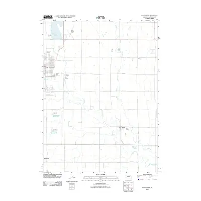
2011 Map of Wahoo East
USGS Topo · Published 2011About this map
Wahoo sits at the western edge of this Saunders County landscape, where the confluence of Sand Creek and Wahoo Creek defines the local topography. To the north, the significant basin of Lake Wanahoo and the prominent Bodleys Hill overlook the river valley, while the Wahoo Municipal Airport and Saunders County Fairgrounds mark the community's modern infrastructure. The map details a transition from the structured street grid of Wahoo to the agricultural surroundings of Ithaca and the small settlement of Swedeburg.
Find a feature on this map
43 named features on this map. Tap any name to fly to it.
Don’t see what you’re looking for? This feature index may not catch every label — zoom into the map to look around manually.
Map Details
Editions of this 2011 Wahoo East Map
This is the sole edition of this map. No revisions or reprints were ever made.
Other maps of this area

1893 · Fremont
USGS Topo · 1:125,000

1896 · Fremont
USGS Topo · 1:125,000

1899 · Wahoo
USGS Topo · 1:125,000

1955 · Fremont
USGS Topo · 1:250,000

1957 · Fremont
USGS Topo · 1:250,000

1958 · Fremont
USGS Topo · 1:250,000

1968 · Leshara
USGS Topo · 1:24,000
1969 · Malmo
USGS Topo · 1:24,000
1969 · Ashland West
USGS Topo · 1:24,000
1969 · Mead
USGS Topo · 1:24,000