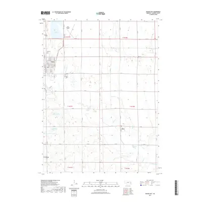
2017 Map of Wahoo East
USGS Topo · Published 2017About this map
Wahoo serves as the primary hub in this eastern Saunders County landscape, where the grid of city streets meets the sprawling agricultural sections of the Nebraska plains. The drainage of Wahoo Creek and Silver Creek dictates the topography, anchored by the significant presence of Lake Wanahoo to the north and a series of managed water bodies like Swedeburg Reservoir 2B-1 to the south. Genealogists can locate several distinct burial grounds serving the local communities, including Greenwood Cem, Sunrise Cem, and Saint Francis Cem near the main settlement, as well as the more remote Alma Cem to the east. Smaller rural centers like Ithaca and Swedeburg mark the intersections of the county road system, while Bodleys Hill provides a rare point of elevation change in a region otherwise defined by its undulating stream valleys and steady agricultural development.
Find a feature on this map
66 named features on this map. Tap any name to fly to it.
Don’t see what you’re looking for? This feature index may not catch every label — zoom into the map to look around manually.
Map Details
Editions of this 2017 Wahoo East Map
This is the sole edition of this map. No revisions or reprints were ever made.
Other maps of this area

1893 · Fremont
USGS Topo · 1:125,000

1896 · Fremont
USGS Topo · 1:125,000

1899 · Wahoo
USGS Topo · 1:125,000

1955 · Fremont
USGS Topo · 1:250,000

1957 · Fremont
USGS Topo · 1:250,000

1958 · Fremont
USGS Topo · 1:250,000

1968 · Leshara
USGS Topo · 1:24,000
1969 · Malmo
USGS Topo · 1:24,000
1969 · Ashland West
USGS Topo · 1:24,000
1969 · Mead
USGS Topo · 1:24,000