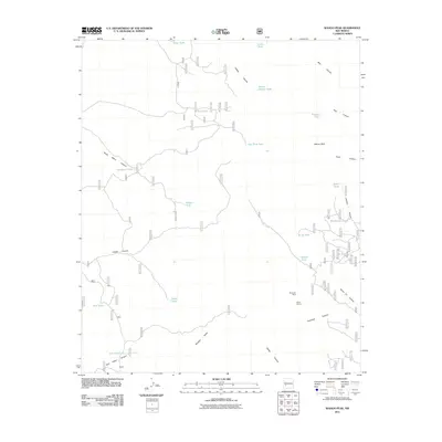
2011 Map of Wahoo Peak
USGS Topo · Published 2011About this map
Wahoo Peak anchors this high-elevation landscape in Catron County, where a complex network of seasonal drainages and man-made water catchments defines the land use. The presence of the Black Box Mine and Bambi Claims suggests a history of mineral prospecting in the canyons east of Silver Creek. This environment is heavily managed for water, as evidenced by the numerous named catchments such as Wahoo Tank, Poison Tank, and Woodcutter Tank, which are essential for livestock or wildlife in an area where permanent water is scarce. The map reveals an intricate grid of forest roads, including 4141j and 4052s, providing access to remote drainage systems like Seven H L Canyon and Antelope Canyon.
Find a feature on this map
81 named features on this map. Tap any name to fly to it.
Don’t see what you’re looking for? This feature index may not catch every label — zoom into the map to look around manually.
Map Details
Editions of this 2011 Wahoo Peak Map
This is the sole edition of this map. No revisions or reprints were ever made.
Other maps of this area

1949 · Lookout Mountain
USGS Topo · 1:62,500

1954 · Tularosa
USGS Topo · 1:250,000

1958 · Tularosa
USGS Topo · 1:250,000

1965 · Iron Mountain
USGS Topo · 1:24,000

1965 · Dusty
USGS Topo · 1:24,000

1965 · Wahoo Peak
USGS Topo · 1:24,000

1979 · Truth or Consequences
USGS Topo · 1:100,000

1979 · San Mateo Mountains
USGS Topo · 1:100,000
1981 · Taylor Peak
USGS Topo · 1:24,000
1981 · Mojonera Canyon
USGS Topo · 1:24,000