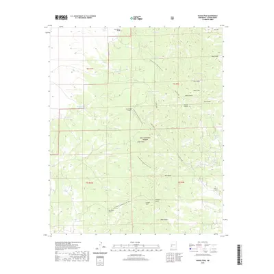
2020 Map of Wahoo Peak
USGS Topo · Published 2020About this map
The Black Range dominates this portion of the Gila National Forest, where the Continental Divide National Scenic Trail winds through high-elevation terrain. This survey reflects a landscape shaped by intermittent water sources, evidenced by numerous named tanks such as Polecat Tank, Hog Tank, and South Wahoo Tank that support the local ecosystem. Significant landmarks like Wahoo Peak and Bear Mtn rise above a series of deeply cut drainages including Wahoo Canyon, Pole Canyon, and Knisely Canyon. The presence of Adobe Spring and Adobe Canyon suggests a history of reliance on these specific water points in a high-desert environment. This documentation captures the area's wild character, with the Continental Divide serving as the primary geographic spine for both topographical drainage and modern recreational paths.
Find a feature on this map
40 named features on this map. Tap any name to fly to it.
Don’t see what you’re looking for? This feature index may not catch every label — zoom into the map to look around manually.
Map Details
Editions of this 2020 Wahoo Peak Map
This is the sole edition of this map. No revisions or reprints were ever made.
Other maps of this area

1949 · Lookout Mountain
USGS Topo · 1:62,500

1954 · Tularosa
USGS Topo · 1:250,000

1958 · Tularosa
USGS Topo · 1:250,000

1965 · Iron Mountain
USGS Topo · 1:24,000

1965 · Dusty
USGS Topo · 1:24,000

1965 · Wahoo Peak
USGS Topo · 1:24,000

1979 · Truth or Consequences
USGS Topo · 1:100,000

1979 · San Mateo Mountains
USGS Topo · 1:100,000
1981 · Taylor Peak
USGS Topo · 1:24,000
1981 · Mojonera Canyon
USGS Topo · 1:24,000