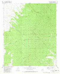
1981 Map of Wahoo Peak
USGS Topo · Published 1981About this map
The Continental Divide winds through this high-altitude landscape in the Gila National Forest, marking the watershed between numerous named canyons. Grounded by the 8,796-foot summit of Wahoo Peak, the terrain is defined by its arid-land water management, featuring a dense network of man-made and natural water sources. These range from isolated basins like Wahoo Tank and Tyson Tank to the critical Adobe Spring and White Saddle Well. The mapping illustrates a landscape managed for cattle and conservation, where drainage systems like Wahoo Canyon and Silver Creek dictate the movement of travelers along established routes. Primitive transportation is documented by the Pack Trail and various jeep trails, which connect these vital water points through complex drainages such as Seven HL Canyon and Adobe Canyon.
Find a feature on this map
36 named features on this map. Tap any name to fly to it.
Don’t see what you’re looking for? This feature index may not catch every label — zoom into the map to look around manually.
Map Details
Editions of this 1981 Wahoo Peak Map
This is the sole edition of this map. No revisions or reprints were ever made.
Other maps of this area

1949 · Lookout Mountain
USGS Topo · 1:62,500

1954 · Tularosa
USGS Topo · 1:250,000

1958 · Tularosa
USGS Topo · 1:250,000

1965 · Iron Mountain
USGS Topo · 1:24,000

1965 · Dusty
USGS Topo · 1:24,000

1965 · Wahoo Peak
USGS Topo · 1:24,000

1979 · Truth or Consequences
USGS Topo · 1:100,000

1979 · San Mateo Mountains
USGS Topo · 1:100,000
1981 · Taylor Peak
USGS Topo · 1:24,000
1981 · Mojonera Canyon
USGS Topo · 1:24,000