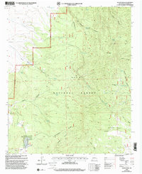
1999 Map of Wahoo Peak
USGS Topo · Published 2002About this map
Wahoo Peak stands as the central landmark in this high-altitude section of the Gila National Forest, where the complex drainage systems of the San Mateo Mountains are meticulously documented. The landscape is defined by its water management infrastructure, essential for ranching and forest maintenance, including Adobe Spring and a vast network of named tanks such as Poison Tank, Dolan Tank, and Dry Time Tank. The Continental Divide National Scenic Trail traverses the ridges, providing a corridor through the deep incisions of Wahoo Canyon and Bear Canyon. This late-twentieth-century revision illustrates the continued importance of remote outposts like White Saddle Well and the Ranger District Boundary in managing these expansive public lands. The transition from gulches like Straight Gulch to broad canyons like Seven H L Canyon reveals a topography shaped by seasonal water flow and long-standing forest service stewardship.
Find a feature on this map
42 named features on this map. Tap any name to fly to it.
Don’t see what you’re looking for? This feature index may not catch every label — zoom into the map to look around manually.
Map Details
Editions of this 1999 Wahoo Peak Map
This is the sole edition of this map. No revisions or reprints were ever made.
Other maps of this area

1949 · Lookout Mountain
USGS Topo · 1:62,500

1954 · Tularosa
USGS Topo · 1:250,000

1958 · Tularosa
USGS Topo · 1:250,000

1965 · Iron Mountain
USGS Topo · 1:24,000

1965 · Dusty
USGS Topo · 1:24,000

1965 · Wahoo Peak
USGS Topo · 1:24,000

1979 · Truth or Consequences
USGS Topo · 1:100,000

1979 · San Mateo Mountains
USGS Topo · 1:100,000
1981 · Taylor Peak
USGS Topo · 1:24,000
1981 · Mojonera Canyon
USGS Topo · 1:24,000