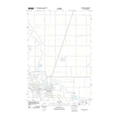
2011 Map of Wahpeton
USGS Topo · Published 2011About this map
The confluence of the Otter Tail River and the Bois de Sioux River forms the Red River of the North at the border of North Dakota and Minnesota, anchoring the twin cities of Wahpeton and Breckenridge. This 2011 survey details a landscape defined by this vital water system, which historically dictated the growth and layout of the region. The map shows the urban grid of Wahpeton extending west of the river, while Breckenridge occupies the eastern bank, featuring the Breckenridge Post Office and residential streets named for many states, including Minnesota Ave and Dacotah Ave.
Find a feature on this map
43 named features on this map. Tap any name to fly to it.
Don’t see what you’re looking for? This feature index may not catch every label — zoom into the map to look around manually.
Map Details
Editions of this 2011 Wahpeton Map
This is the sole edition of this map. No revisions or reprints were ever made.
Other maps of this area

1904 · Wahpeton
USGS Topo · 1:125,000

1919 · Rothsay
USGS Topo · 1:62,500

1951 · Rothsay
USGS Topo · 1:62,500

1951 · Campbell
USGS Topo · 1:62,500

1953 · Fargo
USGS Topo · 1:250,000

1956 · Fargo
USGS Topo · 1:250,000

1964 · Fairmount NW
USGS Topo · 1:24,000

1964 · Dwight
USGS Topo · 1:24,000

1964 · Wahpeton
USGS Topo · 1:24,000
1973 · Abercrombie
USGS Topo · 1:24,000