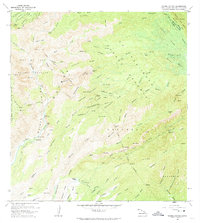
1965 Map of Waimea Canyon
USGS Topo · Published 1974About this map
Waimea Canyon dominates the landscape of western Kauai, where the erosive force of the Waimea River has carved deep into the island's basaltic shield. This mid-1960s field survey details a complex geography of water management and conservation, showing the Na Pali-Kona Forest Reserve and the high-elevation Alakai Swamp. Infrastructure for hydroelectric power and agriculture is evident through the Mauka Powerhouse, a Penstock, and numerous ditch and flume systems that divert water from the interior ridges to the drier lowlands. Historical land use is captured in the network of pack trails and jeep trails that navigate the steep walls of the canyon, connecting remote outposts like the Waialae Cabin to more accessible points like the Waimea Canyon Lookout. Notable vertical features include the dramatic Waipoo Falls and Waianuenue Falls, while the lower Makaweli River valley shows evidence of irrigation at Kepani Res.
Find a feature on this map
103 named features on this map. Tap any name to fly to it.
Don’t see what you’re looking for? This feature index may not catch every label — zoom into the map to look around manually.
Map Details
Editions of this 1965 Waimea Canyon Map
2 editions found
Other maps of this area

1954 · Kauai
USGS Topo · 1:250,000

1963 · Kekaha
USGS Topo · 1:24,000

1963 · Hanapepe
USGS Topo · 1:24,000

1963 · Koloa
USGS Topo · 1:24,000

1963 · Hanalei
USGS Topo · 1:24,000

1965 · Waimea Canyon
USGS Topo · 1:24,000

1965 · Haena
USGS Topo · 1:24,000

1965 · Makaha Point
USGS Topo · 1:24,000

1965 · Waialeale
USGS Topo · 1:24,000

1967 · Kauai
USGS Topo · 1:250,000