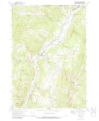
1970 Map of Waitsfield
USGS Topo · Published 1988About this map
The Mad River valley serves as the central corridor for this 1970 Vermont survey, where the river's path dictates the placement of towns like Waitsfield and Moretown. The landscape transitions from the valley floor to the high peaks of the Northfield Mountains and the slopes of the Green Mountain National Forest. Local history is well-preserved through numerous burial grounds, including the Wait Cem and Village Cem, which anchor the early settlements. Small-scale resource extraction is noted by a Quarry in Duxbury and a Mine near the village of South Duxbury. A distinctive Covered Bridge spans the river, reflecting the traditional infrastructure of the Mad River Valley. To the west, the rugged terrain of the Camels Hump State Forest rises toward peaks like Double Top Mtn, while the Lookout Tower on Scrag Mtn provides a vantage point over the southern reaches of the quadrangle.
Find a feature on this map
42 named features on this map. Tap any name to fly to it.
Don’t see what you’re looking for? This feature index may not catch every label — zoom into the map to look around manually.
Map Details
Editions of this 1970 Waitsfield Map
3 editions found
Other maps of this area

1919 · Lincoln Mountain
USGS Topo · 1:62,500

1919 · Montpelier
USGS Topo · 1:62,500

1920 · Lincoln Mountain
USGS Topo · 1:48,000

1921 · Richmond
USGS Topo · 1:48,000

1921 · Lincoln Mountain
USGS Topo · 1:62,500

1921 · Montpelier
USGS Topo · 1:62,500

1922 · Barre
USGS Topo · 1:48,000

1924 · Barre
USGS Topo · 1:62,500

1924 · Camels Hump
USGS Topo · 1:62,500

1944 · Montpelier
USGS Topo · 1:62,500