
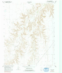
1962 Map of Waka SW
USGS Topo · Published 1965About this map
Deeply incised canyons of the Texas Panhandle define this landscape, where the meandering course of Palo Duro Creek cuts through the High Plains. Surveyed in the early 1960s, the map reveals an environment increasingly shaped by the petroleum industry, dominated by the Hansford North Gas and Oil Field and the Hansford Gas and Oil Field. While the terrain appears largely uninhabited, the dense network of roads and pipelines connecting various wells indicates significant industrial activity within the Oil Field zones. Natural water sources like Spring and Horse Creek provide rare landmarks in a region where topography is primarily shaped by water erosion and geological extraction, including a lone Quarry on the eastern edge of the breaks.
Find a feature on this map
7 named features on this map. Tap any name to fly to it.
Don’t see what you’re looking for? This feature index may not catch every label — zoom into the map to look around manually.
Map Details
Editions of this 1962 Waka SW Map
2 editions found
Other maps of this area

1954 · Perryton
USGS Topo · 1:250,000

1958 · Perryton
USGS Topo · 1:250,000

1962 · Kimball
USGS Topo · 1:24,000

1962 · Hansford Camp
USGS Topo · 1:24,000

1962 · Hansford
USGS Topo · 1:24,000

1962 · Spearman
USGS Topo · 1:24,000

1973 · Horseshoe Hill
USGS Topo · 1:24,000

1973 · Waka
USGS Topo · 1:24,000

1973 · Spearman NE
USGS Topo · 1:24,000

1974 · Bernstein
USGS Topo · 1:24,000