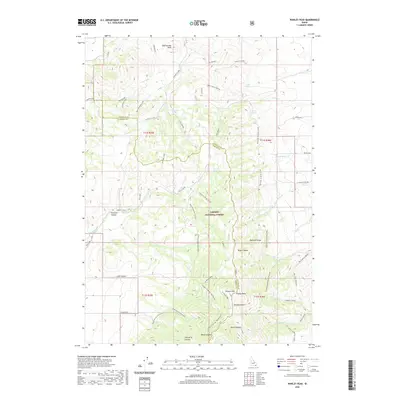
2020 Map of Wakley Peak
USGS Topo · Published 2020About this map
Wakley Peak and the southern reaches of the Bannock Range define the high-elevation landscape of this region along the border of Bannock and Oneida counties. This 2020 survey documents the intersection of public lands and industrial history, notably within the Caribou National Forest. Resource extraction is evidenced by the presence of the Monson Mine and Hills Mine, while the complex drainage network includes Hawkins Creek, Potter Creek, and Wright Creek. The map details a web of specialized access routes, such as the Wright Creek National Recreation Trail and the Wursten Springs Cut-Off, reflecting the area's use for both modern recreation and historic ranching and mining operations in the high Idaho basins.
Find a feature on this map
64 named features on this map. Tap any name to fly to it.
Don’t see what you’re looking for? This feature index may not catch every label — zoom into the map to look around manually.
Map Details
Editions of this 2020 Wakley Peak Map
This is the sole edition of this map. No revisions or reprints were ever made.
Other maps of this area

1954 · Pocatello
USGS Topo · 1:250,000

1958 · Pocatello
USGS Topo · 1:250,000

1963 · Daniels
USGS Topo · 1:24,000

1968 · Daniels
USGS Topo · 1:24,000

1968 · Malad Summit
USGS Topo · 1:24,000

1968 · Dairy Creek
USGS Topo · 1:24,000

1968 · Downey West
USGS Topo · 1:24,000

1968 · Wakley Peak
USGS Topo · 1:24,000
1968 · Elkhorn Peak
USGS Topo · 1:24,000

1968 · Hawkins
USGS Topo · 1:24,000