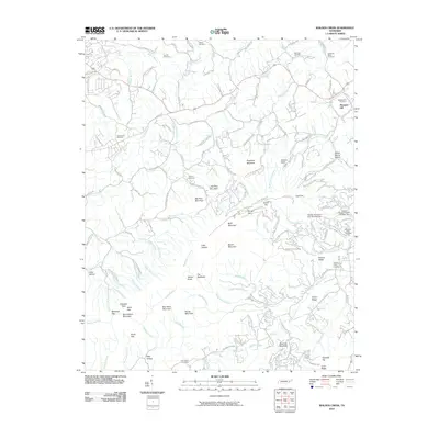
2010 Map of Walden Creek
USGS Topo · Published 2010About this map
Waldens Creek and its many tributaries carve a dense network of hollows through this landscape, defining the rural character south of the Parkway. The area is marked by numerous family and community burial grounds, including Ivy Hill Cemetery, Shiloh Cemetery, and the Chinquapin Cemetery, which serve as vital touchstones for local genealogy. The terrain transitions from the broader valley near Pleasant Hill to the complex ridges of Bluff Mountain and Sugarloaf Mountain. Water management features like Hidden Mountain Dam Number One appear alongside established routes such as the Cherokee Trl and Titsworth Springs Rd, illustrating the intersection of natural topography and residential development. The map detail preserves the placement of isolated gaps and knobs, from Millstone Gap to Headrick Top, providing a clear record of the foothills before further modern expansion.
Find a feature on this map
136 named features on this map. Tap any name to fly to it.
Don’t see what you’re looking for? This feature index may not catch every label — zoom into the map to look around manually.
Map Details
Editions of this 2010 Walden Creek Map
This is the sole edition of this map. No revisions or reprints were ever made.
Other maps of this area

1886 · Knoxville
USGS Topo · 1:125,000

1892 · Knoxville
USGS Topo · 1:125,000

1894 · Knoxville
USGS Topo · 1:125,000

1895 · Knoxville
USGS Topo · 1:125,000

1901 · Knoxville
USGS Topo · 1:125,000

1935 · Knoxville
USGS Topo · 1:48,000

1935 · Walden Creek
USGS Topo · 1:24,000

1935 · Wildwood
USGS Topo · 1:24,000

1935 · Sevierville
USGS Topo · 1:48,000
1935 · Boyds Creek
USGS Topo · 1:24,000