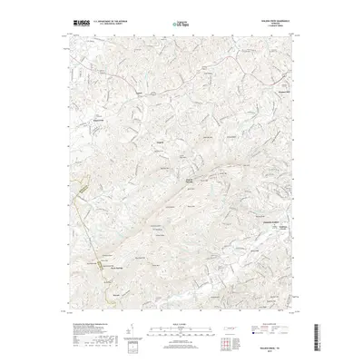
2019 Map of Walden Creek
USGS Topo · Published 2019About this map
Pigeon Forge sits at the edge of this detailed topography, where the landscape rises sharply toward the summits of Chilhowee Mtn and Bluff Mtn. The terrain is defined by a dense network of ridges and watercourses, including the winding Waldens Cr and Ellejoy Cr. Small settlements and family landmarks are scattered throughout the valleys, providing a window into the rural layout of Sevier County. Local history is anchored by several long-standing burial grounds such as Shiloh Cem, Ivy Hill Cem, and the Waldens Creek Cem. The map tracks the passage of US Highway 441 and US Highway 411 as they navigate the base of the Slate Knobs, illustrating how modern infrastructure follows the natural corridors established by the region's complex drainage systems, including Knob Cr and Boyds Cr.
Find a feature on this map
79 named features on this map. Tap any name to fly to it.
Don’t see what you’re looking for? This feature index may not catch every label — zoom into the map to look around manually.
Map Details
Editions of this 2019 Walden Creek Map
This is the sole edition of this map. No revisions or reprints were ever made.
Other maps of this area

1886 · Knoxville
USGS Topo · 1:125,000

1892 · Knoxville
USGS Topo · 1:125,000

1894 · Knoxville
USGS Topo · 1:125,000

1895 · Knoxville
USGS Topo · 1:125,000

1901 · Knoxville
USGS Topo · 1:125,000

1935 · Knoxville
USGS Topo · 1:48,000

1935 · Walden Creek
USGS Topo · 1:24,000

1935 · Wildwood
USGS Topo · 1:24,000

1935 · Sevierville
USGS Topo · 1:48,000
1935 · Boyds Creek
USGS Topo · 1:24,000