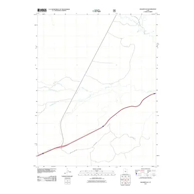
2011 Map of Walker Flat
USGS Topo · Published 2011About this map
Ivie Creek and its tributaries define the drainage of this central Utah landscape in Sevier County, where modern infrastructure meets historical transit routes. The geography is marked by a network of drainage systems including Saleratus Creek and Trough Hollow Creek, which flow through the arid terrain. Transportation is dominated by the corridor of Interstate 70, which bisects the quadrangle, paralleled by more local pathways such as Lower Last Chance Loop. In the northern reaches, Coal Mine Rd and Quitchupah Creek hint at the region's industrial and natural heritage. This 2011 survey serves as a precise record of the road systems and hydrography at the start of the decade, illustrating how County Rd 310 and other backroads connect the open spaces between these significant waterways.
Find a feature on this map
9 named features on this map. Tap any name to fly to it.
Don’t see what you’re looking for? This feature index may not catch every label — zoom into the map to look around manually.
Map Details
Editions of this 2011 Walker Flat Map
This is the sole edition of this map. No revisions or reprints were ever made.
Other maps of this area

1885 · Fish Lake
USGS Topo · 1:250,000

1896 · Fish Lake
USGS Topo · 1:250,000

1922 · Emery No.3
USGS Topo · 1:31,680

1925 · Acord Lakes
USGS Topo · 1:62,500

1956 · Salina
USGS Topo · 1:250,000

1960 · Salina
USGS Topo · 1:250,000

1962 · Salina
USGS Topo · 1:250,000

1968 · Johns Peak
USGS Topo · 1:24,000
1968 · Old Woman Plateau
USGS Topo · 1:24,000
1968 · Walker Flat
USGS Topo · 1:24,000