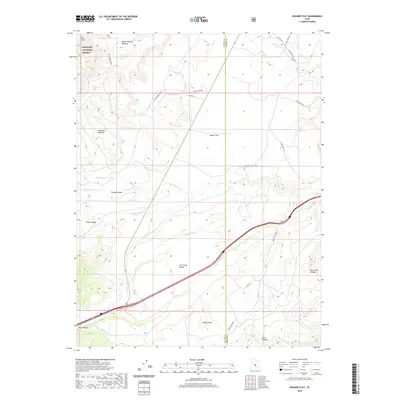
2020 Map of Walker Flat
USGS Topo · Published 2020About this map
Fishlake National Forest dominates the northwestern corner of this Sevier County landscape, where the high terrain of The Cove and Water Hollow Benches gives way to a complex series of plateaus and valleys. The presence of W Hidden Valley Mine and its access along Coal Mine Rd indicates the area's continued industrial activity, situated north of the prominent Ivie Creek Bench. The map reveals a drainage network defined by Saleratus Cr and Ivie Cr, which cut through the level expanses of Walker Flat and Gilson Valley. Numerous secondary routes and springs, including Windy Peak Spr, suggest a landscape historically utilized for both resource extraction and grazing. The boundary between Sevier and Emery counties bisects the eastern half, providing a clear reference for researchers tracking land use and jurisdictional history across these high desert basins.
Find a feature on this map
31 named features on this map. Tap any name to fly to it.
Don’t see what you’re looking for? This feature index may not catch every label — zoom into the map to look around manually.
Map Details
Editions of this 2020 Walker Flat Map
This is the sole edition of this map. No revisions or reprints were ever made.
Other maps of this area

1885 · Fish Lake
USGS Topo · 1:250,000

1896 · Fish Lake
USGS Topo · 1:250,000

1922 · Emery No.3
USGS Topo · 1:31,680

1925 · Acord Lakes
USGS Topo · 1:62,500

1956 · Salina
USGS Topo · 1:250,000

1960 · Salina
USGS Topo · 1:250,000

1962 · Salina
USGS Topo · 1:250,000

1968 · Johns Peak
USGS Topo · 1:24,000
1968 · Old Woman Plateau
USGS Topo · 1:24,000
1968 · Walker Flat
USGS Topo · 1:24,000