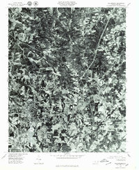
1977 Map of Walkertown
USGS Topo · Published 1979About this map
The agricultural and residential landscape of Forsyth County is captured in this orthophotomap, showing the northward expansion of Winston-Salem during the late 1970s. The aerial imagery highlights the distinct transition from the established suburban development of Brookwood and Montview to the more dispersed rural patterns near Dennis. Central to this area is Walkertown, where the clustering of structures suggests its role as a local crossroads hub. This specific mapping technique, which uses rectified photo-imagery, provides a literal view of the land use of the era, from the cleared farm fields and woodlots to the wooded banks of Belews Creek. Unlike a traditional topographic map, this survey preserves the exact texture of the North Carolina Piedmont as it appeared on the morning of March 15, 1977.
Find a feature on this map
6 named features on this map. Tap any name to fly to it.
Don’t see what you’re looking for? This feature index may not catch every label — zoom into the map to look around manually.
Map Details
Editions of this 1977 Walkertown Map
This is the sole edition of this map. No revisions or reprints were ever made.
Other maps of this area

1950 · Winston-Salem West
USGS Topo · 1:24,000

1950 · Winston-Salem East
USGS Topo · 1:24,000

1951 · Winston-Salem West
USGS Topo · 1:24,000

1951 · Winston-Salem East
USGS Topo · 1:24,000

1951 · Rural Hall
USGS Topo · 1:24,000

1951 · Walkertown
USGS Topo · 1:24,000

1953 · Winston-Salem
USGS Topo · 1:250,000

1955 · Winston-Salem
USGS Topo · 1:250,000

1962 · Winston-Salem
USGS Topo · 1:250,000

1964 · King
USGS Topo · 1:24,000