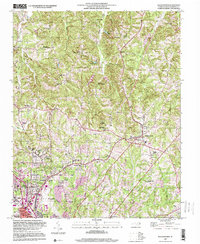
1997 Map of Walkertown
USGS Topo · Published 2000About this map
Walkertown serves as a primary hub in this Forsyth County landscape, where rural church communities and early industrial sites intersect. The Norfolk and Western railroad corridor anchors the southern geography, passing through Ogtum Sta and connecting with the infrastructure surrounding Smith Reynolds Airport. The map documents a dense network of local landmarks, including the Memorial Industrial Sch and numerous cemeteries such as Banner Cem and Sullivan Cem, which offer significant value for genealogical research.
Find a feature on this map
58 named features on this map. Tap any name to fly to it.
Don’t see what you’re looking for? This feature index may not catch every label — zoom into the map to look around manually.
Map Details
Editions of this 1997 Walkertown Map
This is the sole edition of this map. No revisions or reprints were ever made.
Other maps of this area

1950 · Winston-Salem West
USGS Topo · 1:24,000

1950 · Winston-Salem East
USGS Topo · 1:24,000

1951 · Winston-Salem West
USGS Topo · 1:24,000

1951 · Winston-Salem East
USGS Topo · 1:24,000

1951 · Rural Hall
USGS Topo · 1:24,000

1951 · Walkertown
USGS Topo · 1:24,000

1953 · Winston-Salem
USGS Topo · 1:250,000

1955 · Winston-Salem
USGS Topo · 1:250,000

1962 · Winston-Salem
USGS Topo · 1:250,000

1964 · King
USGS Topo · 1:24,000