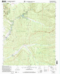
1999 Map of Wall Lake
USGS Topo · Published 2002About this map
Wall Lake and the winding course of Taylor Creek form the central features of this high-elevation landscape, where the Gila National Forest meets several designated wilderness areas. The map details a transition from the structured waters of Wall Lake to the complex drainage systems of Diamond Creek and Whitewater Creek in the east. Human presence is marked by isolated outposts such as Links Ranch and D Bar Ranch, alongside early mining activity evidenced by Mine and Prospects labels near the northern boundary. The confluence of the Fork Gila River and Beaver Creek highlights the drainage patterns that have shaped this terrain. The convergence of the Aldo Leopold Wilderness, Gila Wilderness, and Black Range Wilderness underscores the protected nature of this region at the turn of the 21st century, showing a landscape defined by canyons and essential water sources like Pot Hole Tank and Cobb Well.
Find a feature on this map
50 named features on this map. Tap any name to fly to it.
Don’t see what you’re looking for? This feature index may not catch every label — zoom into the map to look around manually.
Map Details
Editions of this 1999 Wall Lake Map
This is the sole edition of this map. No revisions or reprints were ever made.
Other maps of this area

1911 · Alum Mountain
USGS Topo · 1:125,000

1913 · Alum Mountain
USGS Topo · 1:125,000

1949 · Lookout Mountain
USGS Topo · 1:62,500

1954 · Tularosa
USGS Topo · 1:250,000

1954 · Clifton
USGS Topo · 1:250,000

1957 · Clifton
USGS Topo · 1:250,000

1958 · Clifton
USGS Topo · 1:250,000

1958 · Tularosa
USGS Topo · 1:250,000

1962 · Clifton
USGS Topo · 1:250,000

1963 · Bonner Canyon
USGS Topo · 1:24,000