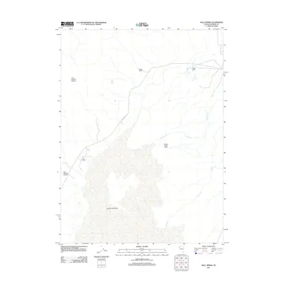
2011 Map of Wall Spring
USGS Topo · Published 2011About this map
Smoke Creek Desert dominates the southern portion of this Washoe County landscape, illustrating the stark topography of the Great Basin. To the north, the terrain transitions into complex drainage systems and canyons, including Little Sawmill Canyon and Five Springs Canyon. The human presence is sparse, anchored by the Parker Ranch near Wall Spring, highlighting the critical importance of water sources in this arid environment. Transportation through the region is primary facilitated by Smoke Creek Rd, which winds past landmarks like Indian Rock and the seasonal flows of Squaw Creek. This 2011 survey documents the persistent ranching and geographic features of the Nevada high desert, from the open expanses of Freds Field to the tucked-away Indian Rock Spring.
Find a feature on this map
12 named features on this map. Tap any name to fly to it.
Don’t see what you’re looking for? This feature index may not catch every label — zoom into the map to look around manually.
Map Details
Editions of this 2011 Wall Spring Map
This is the sole edition of this map. No revisions or reprints were ever made.
Other maps of this area

1886 · Granite Range
USGS Topo · 1:250,000

1894 · Granite Range
USGS Topo · 1:250,000

1955 · Lovelock
USGS Topo · 1:250,000

1959 · Lovelock
USGS Topo · 1:250,000

1964 · Gerlach
USGS Topo · 1:62,500
1980 · The Banjo
USGS Topo · 1:24,000

1980 · Hog Spring
USGS Topo · 1:24,000

1980 · Wall Spring
USGS Topo · 1:24,000

1980 · Smith Canyon
USGS Topo · 1:24,000
1981 · Squaw Valley
USGS Topo · 1:24,000