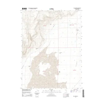
2014 Map of Wall Spring
USGS Topo · Published 2014About this map
Smoke Creek Desert dominates the southern reaches of this landscape, its expansive alkali flats meeting the rising topographic contours of the surrounding high desert. This corner of Washoe County is defined by its scarce water sources, where Wall Spring and Indian Rock Spring provided critical relief for those traversing the arid terrain. The map traces the intermittent paths of Squaw Cr and Dry Cr, which flow through the Squaw Creek Valley during seasonal runoff.
Find a feature on this map
16 named features on this map. Tap any name to fly to it.
Don’t see what you’re looking for? This feature index may not catch every label — zoom into the map to look around manually.
Map Details
Editions of this 2014 Wall Spring Map
This is the sole edition of this map. No revisions or reprints were ever made.
Other maps of this area

1886 · Granite Range
USGS Topo · 1:250,000

1894 · Granite Range
USGS Topo · 1:250,000

1955 · Lovelock
USGS Topo · 1:250,000

1959 · Lovelock
USGS Topo · 1:250,000

1964 · Gerlach
USGS Topo · 1:62,500
1980 · The Banjo
USGS Topo · 1:24,000

1980 · Hog Spring
USGS Topo · 1:24,000

1980 · Wall Spring
USGS Topo · 1:24,000

1980 · Smith Canyon
USGS Topo · 1:24,000
1981 · Squaw Valley
USGS Topo · 1:24,000