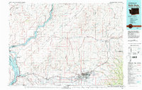
1980 Map of Walla Walla
USGS Topo · Published 1980About this map
Walla Walla serves as the regional hub for this 1980 survey, where the concentrated urban grid of the city meets the agricultural expanse of the Walla Walla Valley. The map documents the city's established institutional landscape, including the Whitman College campus, the historic grounds of Fort Walla Walla, and St. Marys Hospital. To the west, the arid Eureka Flat and the Sand Dunes near the confluence of the Snake River and Columbia River illustrate the dramatic transition from irrigated valley floor to the high desert terrain of the Horse Heaven Hills.
Find a feature on this map
116 named features on this map. Tap any name to fly to it.
Don’t see what you’re looking for? This feature index may not catch every label — zoom into the map to look around manually.
Map Details
Editions of this 1980 Walla Walla Map
2 editions found
Other maps of this area

1908 · Umatilla
USGS Topo · 1:125,000

1915 · Wallulah
USGS Topo · 1:96,000

1916 · Connell
USGS Topo · 1:125,000

1917 · Pasco
USGS Topo · 1:125,000

1918 · Connell
USGS Topo · 1:125,000

1918 · Wallula
USGS Topo · 1:125,000

1919 · Walla Walla
USGS Topo · 1:125,000

1921 · Walla Walla
USGS Topo · 1:125,000

1925 · Scooteney Lake
USGS Topo · 1:62,500

1935 · Pendleton
USGS Topo · 1:125,000