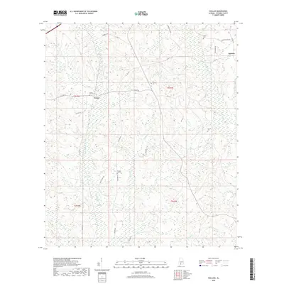
2018 Map of Wallace
USGS Topo · Published 2018About this map
Little Escambia Cr and Wild Fork Cr dominate the drainage patterns of this Escambia County landscape, carving through the terrain near the small community of Wallace. The area's history is preserved in its numerous rural burial grounds, including Wallace Church Cem, Hanberry Cem, and Pleasant Hill Cem, which serve as vital markers for local genealogical research. In the northeast corner, the settlement of Appleton sits near the headwaters of Burnt Corn Cr. The local road network is a mix of established routes like Co Rd 40 and more descriptive paths such as Three Fingers Loop and Fish Hook Rd. A notable legacy of early conservation work is visible in the presence of the CCC Trl, referencing the Civilian Conservation Corps' impact on the Alabama landscape. To the south, the waters of Chavers Cr and Franklin Mill Cr hint at the historical reliance on local waterways for industry and navigation.
Find a feature on this map
36 named features on this map. Tap any name to fly to it.
Don’t see what you’re looking for? This feature index may not catch every label — zoom into the map to look around manually.
Map Details
Editions of this 2018 Wallace Map
This is the sole edition of this map. No revisions or reprints were ever made.
Other maps of this area

1953 · Andalusia
USGS Topo · 1:250,000

1957 · Andalusia
USGS Topo · 1:250,000

1959 · Brewton South
USGS Topo · 1:24,000

1960 · Brewton South
USGS Topo · 1:24,000

1960 · Pollard
USGS Topo · 1:24,000

1960 · Brewton North
USGS Topo · 1:24,000

1960 · Barnett Crossroads
USGS Topo · 1:24,000

1960 · Wallace
USGS Topo · 1:24,000
1960 · Flomaton
USGS Topo · 1:24,000

1971 · Range
USGS Topo · 1:24,000