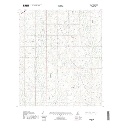
2020 Map of Wallace
USGS Topo · Published 2020About this map
Wallace serves as a central point of interest in this portion of Escambia County, where the landscape is defined by a dense network of tributaries flowing toward the larger river basins of southern Alabama. The settlement is anchored by Wallace Church and the nearby Wallace Church Cem, providing a focal point for genealogical research in this rural area. To the east, the community of Appleton sits near the headwaters of Burnt Corn Cr, while the southern reaches of the map are drained by Franklin Mill Cr and Sevenmile Cr. The terrain is characterized by numerous family and community burial grounds, including Hanberry Cem, Hammac Cem, and Cooper Cem, which are linked by a web of local roads such as Wallace Rd and Co Rd 40. This network of waterways and cemeteries suggests a long-standing pattern of dispersed rural settlement dependent on the local creek system.
Find a feature on this map
35 named features on this map. Tap any name to fly to it.
Don’t see what you’re looking for? This feature index may not catch every label — zoom into the map to look around manually.
Map Details
Editions of this 2020 Wallace Map
This is the sole edition of this map. No revisions or reprints were ever made.
Other maps of this area

1953 · Andalusia
USGS Topo · 1:250,000

1957 · Andalusia
USGS Topo · 1:250,000

1959 · Brewton South
USGS Topo · 1:24,000

1960 · Brewton South
USGS Topo · 1:24,000

1960 · Pollard
USGS Topo · 1:24,000

1960 · Brewton North
USGS Topo · 1:24,000

1960 · Barnett Crossroads
USGS Topo · 1:24,000

1960 · Wallace
USGS Topo · 1:24,000
1960 · Flomaton
USGS Topo · 1:24,000

1971 · Range
USGS Topo · 1:24,000