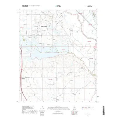
2020 Map of Wallace Lake
USGS Topo · Published 2020About this map
Shreveport’s southern expansion meets the winding wetlands of the Red River valley in this detailed 2020 study of the Caddo and De Soto Parish border. The landscape is defined by the expansive Wallace Lake, which dominates the central terrain alongside numerous waterways like Bayou Pierre, Kelly Bayou, and Gandy Bayou. This modern survey documents a mix of suburban residential growth in the north and the persistence of rural heritage to the south, where small communities like Norton, Stonewall, and Naylor remain key focal points. Local history and genealogy researchers can find several distinct burial grounds and places of worship, including Bethel Church Cemetery, Good Hope Church Cemetery, and the White-Lattier Cemetery. The map also captures local aviation history through Naylor Airport and Ellerbe Field, illustrating how the region's transport and infrastructure have adapted to the low-lying bayou country.
Find a feature on this map
117 named features on this map. Tap any name to fly to it.
Don’t see what you’re looking for? This feature index may not catch every label — zoom into the map to look around manually.
Map Details
Editions of this 2020 Wallace Lake Map
This is the sole edition of this map. No revisions or reprints were ever made.
Other maps of this area

1938 · Arnsberg
USGS Topo · 1:31,680

1941 · Forbing
USGS Topo · 1:31,680

1945 · Grand Cane
USGS Topo · 1:62,500

1945 · Greenwood
USGS Topo · 1:62,500

1945 · Mansfield
USGS Topo · 1:62,500

1947 · Mansfield
USGS Topo · 1:62,500

1948 · Caspiana
USGS Topo · 1:62,500

1955 · Shreveport
USGS Topo · 1:250,000

1955 · Shreveport East
USGS Topo · 1:24,000

1955 · Caspiana
USGS Topo · 1:62,500