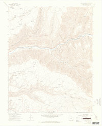
1963 Map of Wallace Ranch
USGS Topo · Published 1965About this map
The Dolores River carves a deep path through the high plateau country of Montezuma County, dividing the expansive Taylor Mesa from the southern reaches of Haycamp Mesa. This mid-century survey reveals a landscape defined by water management and high-altitude ranching, where numerous small water features like Black Reservoir, Copinger Reservoir, and Fivemile Reservoir support the arid uplands. The San Juan National Forest encompasses much of this terrain, showing a network of specialized access routes including the Highline and various jeep trails. These pathways connect isolated points of interest such as the Wallace Ranch and Circle K Ranch, indicating a period when the local economy relied heavily on seasonal grazing and timber management within the national forest boundaries. Tracing the drainages like Priest Gulch and Stewart Gulch offers insight into the natural watershed patterns before modern development altered the area.
Find a feature on this map
61 named features on this map. Tap any name to fly to it.
Don’t see what you’re looking for? This feature index may not catch every label — zoom into the map to look around manually.
Map Details
Editions of this 1963 Wallace Ranch Map
4 editions found

Other maps of this area

1895 · La Plata
USGS Topo · 1:62,500

1897 · La Plata
USGS Topo · 1:62,500

1897 · Rico
USGS Topo · 1:62,500

1898 · Rico
USGS Topo · 1:62,500

1899 · La Plata
USGS Topo · 1:62,500

1899 · Rico
USGS Topo · 1:62,500

1908 · La Plata
USGS Topo · 1:62,500

1956 · Cortez
USGS Topo · 1:250,000

1958 · Cortez
USGS Topo · 1:250,000

1959 · Cortez
USGS Topo · 1:250,000