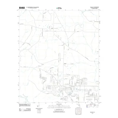
2012 Map of Wallace
USGS Topo · Published 2012About this map
The unincorporated community of Wallace serves as a central hub for this rural landscape in Santa Rosa County, where residential development branches out along a network of numbered and family-named roads. To the south, the sprawling infrastructure of Spencer Naval Outlying Field contrasts with the surrounding agricultural and wooded tracts. The geography is defined by a dense drainage system of creeks and branches, most notably Sevenmile Cr and Tenmile Cr, which meander toward larger water bodies like Blue Lake and Burnt Cypress Lake. Navigation through the area is marked by local landmarks such as the Pace Lookout Tower and the J-22 Ranch Airport. The map documents a transition from traditional timber and farm parcels to suburban subdivisions, visible in the intricate street grids appearing near Beale Cr and Hurricane Br.
Find a feature on this map
124 named features on this map. Tap any name to fly to it.
Don’t see what you’re looking for? This feature index may not catch every label — zoom into the map to look around manually.
Map Details
Editions of this 2012 Wallace Map
This is the sole edition of this map. No revisions or reprints were ever made.
Other maps of this area

1920 · Milton
USGS Topo · 1:62,500

1921 · Muscogee
USGS Topo · 1:62,500

1941 · Muscogee
USGS Topo · 1:62,500

1941 · Milton
USGS Topo · 1:62,500

1941 · Century
USGS Topo · 1:62,500

1943 · Muscogee
USGS Topo · 1:62,500

1943 · Century
USGS Topo · 1:62,500

1943 · Milton
USGS Topo · 1:62,500

1943 · Jay
USGS Topo · 1:62,500
1944 · Floridatown
USGS Topo · 1:25,000