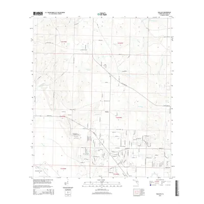
2015 Map of Wallace
USGS Topo · Published 2015About this map
The unincorporated community of Wallace serves as the central hub of this Florida Panhandle landscape, where the coastal plain begins its transition into a network of creek drainages. The area is defined by a dense system of waterways that flow toward the Escambia River basin, including the meandering Buffalo Mill Cr and Sevenmile Cr. To the southwest, the topography flattens significantly as the White River and Blue Lake emerge near Brosnaham Island, a region characterized by low-lying wetlands and Burnt Cypress Lake. Transport and infrastructure are represented by the private J-22 Ranch Airport and a grid of rural routes such as Quintette Rd and Willard Norris Rd. This survey captures the rural residential development patterns of Santa Rosa County, showing how modern neighborhoods have integrated into the historical agricultural and timber tracts near Tenmile Cr and Pond Cr.
Find a feature on this map
136 named features on this map. Tap any name to fly to it.
Don’t see what you’re looking for? This feature index may not catch every label — zoom into the map to look around manually.
Map Details
Editions of this 2015 Wallace Map
This is the sole edition of this map. No revisions or reprints were ever made.
Other maps of this area

1920 · Milton
USGS Topo · 1:62,500

1921 · Muscogee
USGS Topo · 1:62,500

1941 · Muscogee
USGS Topo · 1:62,500

1941 · Milton
USGS Topo · 1:62,500

1941 · Century
USGS Topo · 1:62,500

1943 · Muscogee
USGS Topo · 1:62,500

1943 · Century
USGS Topo · 1:62,500

1943 · Milton
USGS Topo · 1:62,500

1943 · Jay
USGS Topo · 1:62,500
1944 · Floridatown
USGS Topo · 1:25,000