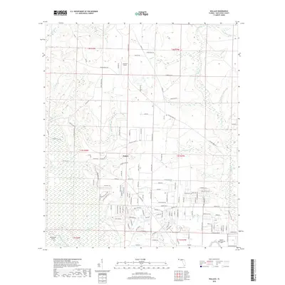
2018 Map of Wallace
USGS Topo · Published 2018About this map
Wallace serves as the central hub for this portion of Santa Rosa County, where rural residential growth meets a landscape defined by an intricate network of coastal plain waterways. The southern reaches are dominated by the wetlands and braids of the White River, featuring landmarks like Brosnaham Island and Burnt Cypress Lake. The presence of the Spencer Naval Outlying Field in the southeast corner provides a clear indication of the region's long-standing connection to aviation and military training operations, a theme echoed further north by the J-22 Ranch Airport. The terrain is characterized by numerous small drainage systems, including Mash Br, Hurricane Br, and Buffalo Mill Cr, which carve into the timbered uplands. This 2018 survey reveals a transition toward organized suburban development while maintaining the traditional Creek and Branch nomenclature that has defined the Florida panhandle for generations.
Find a feature on this map
132 named features on this map. Tap any name to fly to it.
Don’t see what you’re looking for? This feature index may not catch every label — zoom into the map to look around manually.
Map Details
Editions of this 2018 Wallace Map
This is the sole edition of this map. No revisions or reprints were ever made.
Other maps of this area

1920 · Milton
USGS Topo · 1:62,500

1921 · Muscogee
USGS Topo · 1:62,500

1941 · Muscogee
USGS Topo · 1:62,500

1941 · Milton
USGS Topo · 1:62,500

1941 · Century
USGS Topo · 1:62,500

1943 · Muscogee
USGS Topo · 1:62,500

1943 · Century
USGS Topo · 1:62,500

1943 · Milton
USGS Topo · 1:62,500

1943 · Jay
USGS Topo · 1:62,500
1944 · Floridatown
USGS Topo · 1:25,000