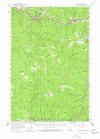
1957 Map of Wallace
USGS Topo · Published 1978About this map
Wallace and the South Fork Coeur d'Alene River valley serve as the industrial and civic heart of this mid-century survey. The landscape is defined by the intensive extraction of the Coeur d'Alene mining district, with major operations like the Morning Mine and Galena Mine dominating the slopes near Mullan and Silverton. This era shows a high-density mining economy where settlements, industrial mills, and dedicated worker burial grounds like the Miners Union Cemetery are closely integrated. The transportation network is remarkably complex for the mountain terrain, featuring the Union Pacific Railroad in the north and the Chicago Milwaukee St Paul and Pacific Railroad winding along the St Joe River in the south. Between these two corridors lies a high-altitude wilderness spanning the Coeur d'Alene National Forest and St Joe National Forest, dotted with lookouts and peaks like Stevens Pk and Mastodon Mtn.
Find a feature on this map
145 named features on this map. Tap any name to fly to it.
Don’t see what you’re looking for? This feature index may not catch every label — zoom into the map to look around manually.
Map Details
Editions of this 1957 Wallace Map
3 editions found

Other maps of this area

1901 · Coeur D'Alene District
USGS Topo · 1:62,500

1903 · Coeur D'Alene District
USGS Topo · 1:62,500

1906 · Coeur D'Alene District
USGS Topo · 1:62,500

1909 · Cataldo
USGS Topo · 1:125,000

1911 · Cataldo
USGS Topo · 1:125,000

1914 · Avery
USGS Topo · 1:125,000

1917 · Avery
USGS Topo · 1:125,000

1932 · Trout Creek
USGS Topo · 1:125,000

1935 · Trout Creek
USGS Topo · 1:125,000

1936 · Trout Creek
USGS Topo · 1:125,000