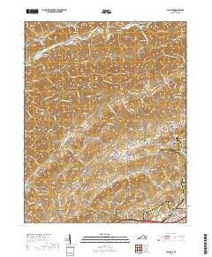
2019 Map of Wallace
USGS Topo · Published 2019About this map
Clinch Mountain and Walker Mtn define the northeast-to-southwest ridges of Washington County, creating a series of parallel valleys such as Poor Valley and Rich Valley. This landscape is marked by a deep-rooted pattern of family-named hollows and gaps, including Wooten Gap and Smiley Hollow, where small settlements like Benhams and Haskell emerged. The northern reaches follow the North Fork Holston River near Craigs Mill, while the southern portion transitions toward the urban edge of Bristol. This 2019 survey documents a dense network of country cemeteries, such as Riverview Cem and Baltzell Cem, often situated near small congregational centers like Clear Branch Church Cem. The terrain reveals how early road networks followed the natural contours of Big Jack Ridge and Countiss Ridge to connect isolated farmsteads at Burson Place and Caney Valley.
Find a feature on this map
161 named features on this map. Tap any name to fly to it.
Don’t see what you’re looking for? This feature index may not catch every label — zoom into the map to look around manually.
Map Details
Editions of this 2019 Wallace Map
This is the sole edition of this map. No revisions or reprints were ever made.
Other maps of this area

1897 · Bristol
USGS Topo · 1:125,000

1902 · Bristol
USGS Topo · 1:125,000

1918 · Carterton
USGS Topo · 1:62,500

1920 · Coeburn
USGS Topo · 1:48,000

1934 · Wallace
USGS Topo · 1:24,000

1934 · Holston Valley
USGS Topo · 1:24,000

1934 · Brumley
USGS Topo · 1:24,000

1934 · Hansonville
USGS Topo · 1:24,000

1934 · Wyndale
USGS Topo · 1:24,000

1934 · Bristol
USGS Topo · 1:24,000