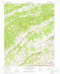
1960 Map of Wallace
USGS Topo · Published 1970About this map
Walker Mountain and Clinch Mtn anchor this Virginia landscape, where the long ridges of the Appalachians dictate the path of travel and settlement. Between these heights, the North Fork Holston River winds through Horseshoe Bend, passing historical sites like Craigs Mill and the Buffalo Ford cemetery. The valley floor is a network of small family-named hollows and gaps, such as Robinette Gap and Smiley Hollow, where agricultural life centered around dozens of small community institutions. The 1960 revision by the Tennessee Valley Authority highlights the evolving infrastructure of the era, from the established tracks of the Norfolk and Western RR and Southern RR to the development of Clear Creek Lake. Dozens of named cemeteries and churches, including Cedar Grove Ch and Riverview Cem, provide a detailed record for genealogical study in settlements like Benhams and Wallace.
Find a feature on this map
94 named features on this map. Tap any name to fly to it.
Don’t see what you’re looking for? This feature index may not catch every label — zoom into the map to look around manually.
Map Details
Editions of this 1960 Wallace Map
2 editions found
Other maps of this area

1897 · Bristol
USGS Topo · 1:125,000

1902 · Bristol
USGS Topo · 1:125,000

1918 · Carterton
USGS Topo · 1:62,500

1920 · Coeburn
USGS Topo · 1:48,000

1934 · Wallace
USGS Topo · 1:24,000

1934 · Holston Valley
USGS Topo · 1:24,000

1934 · Brumley
USGS Topo · 1:24,000

1934 · Hansonville
USGS Topo · 1:24,000

1934 · Wyndale
USGS Topo · 1:24,000

1934 · Bristol
USGS Topo · 1:24,000