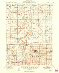
1949 Map of Walnut
USGS Topo · Published 1949About this map
The Green River and its intricate drainage network define this 1940s landscape, where the Green River Wildlife Refuge sits alongside numerous engineered waterways like the Canal and Feeder. The area serves as a busy junction for the Chicago and North Western and Chicago Burlington and Quincy railroads, which support established communities like Walnut, Harmon, and New Bedford. A dense rural infrastructure of small schoolhouses, including Manion Sch, Sturtz Sch, and Allpress Sch, suggests a highly organized agrarian society during this era. Local history and genealogy are preserved at sites like Holy Cross Cem and Centenary Cem. The inclusion of an Airway Beacon near the Lee and Bureau County line highlights the modernization of navigation as air travel began to intersect with the traditional rail and river corridors of north-central Illinois.
Find a feature on this map
60 named features on this map. Tap any name to fly to it.
Don’t see what you’re looking for? This feature index may not catch every label — zoom into the map to look around manually.
Map Details
Editions of this 1949 Walnut Map
3 editions found

Other maps of this area

1893 · Hennepin
USGS Topo · 1:62,500

1909 · Hennepin
USGS Topo · 1:62,500

1911 · Hennepin
USGS Topo · 1:62,500

1918 · Dixon
USGS Topo · 1:62,500

1921 · Buda
USGS Topo · 1:62,500

1923 · Buda
USGS Topo · 1:62,500

1929 · Annawan
USGS Topo · 1:62,500

1930 · Woodsung
USGS Topo · 1:48,000

1932 · Prophetstown
USGS Topo · 1:48,000

1932 · Annawan
USGS Topo · 1:62,500