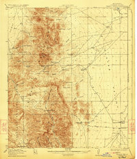
1918 Map of Walnut Wells
USGS Topo · Published 1923About this map
Animas Mountains dominate the western half of this 1917–1918 survey, their sharp peaks like Gillespie Mtn giving way to the broad flats of the Animas Valley and the Playas Valley. The landscape is defined by its remote ranching outposts and early mining ventures in the high desert of Hidalgo County. The map documents the presence of several homesteads and operations including the Red Hill Mine and Gillespie Mine, reflecting a period of extraction and exploration. Water, the most precious resource here, is traced through named springs like Gillespie Spring and seasonal drainages such as Cottonwood Creek. The eastern portion of the map is dominated by the dry Playas and the basin of Playas Lake, while cattle ranching is evidenced by sites like Walnut Wells, Tullous Ranch, and Deatons Ranch. Much of the mountainous terrain falls within the Coronado National Forest, showing a land transition between protected forest and open valley.
Find a feature on this map
55 named features on this map. Tap any name to fly to it.
Don’t see what you’re looking for? This feature index may not catch every label — zoom into the map to look around manually.
Map Details
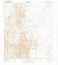
Editions of this 1918 Walnut Wells Map
3 editions found
Other maps of this area

1917 · Antelope Wells
USGS Topo · 1:62,500

1918 · Big Hatchet Peak
USGS Topo · 1:62,500

1918 · Hachita
USGS Topo · 1:62,500

1918 · Dog Mountains
USGS Topo · 1:62,500

1918 · Walnut Wells
USGS Topo · 1:62,500

1918 · Cienega Springs
USGS Topo · 1:62,500

1918 · Playas
USGS Topo · 1:62,500

1918 · Animas Peak
USGS Topo · 1:62,500

1918 · Pratt
USGS Topo · 1:62,500

1919 · Pratt
USGS Topo · 1:62,500