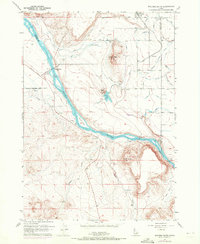
1957 Map of Walters Butte
USGS Topo · Published 1972About this map
The Snake River carves a deep path through this volcanic landscape along the border of Canyon and Owyhee counties, anchoring a region defined by its reliance on early irrigation and river crossings. High above the water, Walters Ferry (Site) marks an important historical transition point where the Owyhee Highway meets the river's edge. The rugged uplands are dominated by volcanic features like Walters Butte, White Butte, and Guffey Butte, while the lower benches show a complex network of water management, including the Waldvogel Canal and numerous laterals like the Midway Lateral.
Find a feature on this map
34 named features on this map. Tap any name to fly to it.
Don’t see what you’re looking for? This feature index may not catch every label — zoom into the map to look around manually.
Map Details
Editions of this 1957 Walters Butte Map
3 editions found
Other maps of this area

1892 · Bisuka
USGS Topo · 1:125,000

1892 · Silver City
USGS Topo · 1:125,000

1894 · Bisuka
USGS Topo · 1:125,000

1894 · Silver City
USGS Topo · 1:125,000

1898 · Silver City
USGS Topo · 1:125,000

1948 · Sinker Butte
USGS Topo · 1:24,000

1949 · Sinker Butte
USGS Topo · 1:24,000

1949 · Oreana
USGS Topo · 1:62,500

1955 · Boise
USGS Topo · 1:250,000
1957 · Walters Butte
USGS Topo · 1:24,000