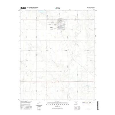
2016 Map of Walters
USGS Topo · Published 2016About this map
Walters serves as the central hub of Cotton County in this 2016 survey, where an organized grid of streets like N Broadway St and E Oklahoma Ave meet the rural expanses of southern Oklahoma. The landscape is defined by the winding course of E Cache Cr and Soldier Cr, which carve through the plains. Local history and genealogy researchers will find the Walters Cem located just north of the town center, while the more remote Brown Cem sits to the south near the creek banks. Water management and recreation are visible at Dave Boyer Lake and Temple Lake, illustrating how the community interacts with the local watershed. This map provides a clear view of the modern county road system, including Co RD n2610 and Co RD e1840, which facilitate movement across this agrarian terrain.
Find a feature on this map
59 named features on this map. Tap any name to fly to it.
Don’t see what you’re looking for? This feature index may not catch every label — zoom into the map to look around manually.
Map Details
Editions of this 2016 Walters Map
This is the sole edition of this map. No revisions or reprints were ever made.
Other maps of this area

1955 · Lawton
USGS Topo · 1:250,000

1957 · Hastings
USGS Topo · 1:62,500

1957 · Randlett
USGS Topo · 1:62,500

1962 · Walters
USGS Topo · 1:62,500

1962 · Temple
USGS Topo · 1:62,500

1984 · Hooper
USGS Topo · 1:24,000
1985 · Randlett
USGS Topo · 1:24,000
1985 · Taylor
USGS Topo · 1:24,000

1985 · Burkburnett
USGS Topo · 1:100,000
1987 · Walters NE
USGS Topo · 1:24,000