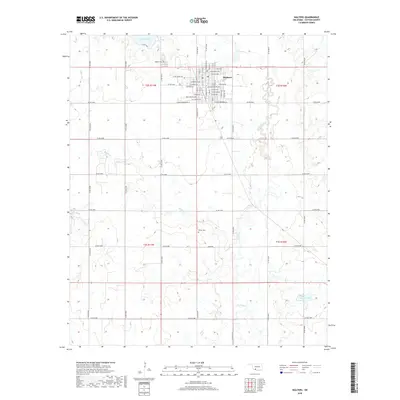
2018 Map of Walters
USGS Topo · Published 2018About this map
Walters serves as the central hub for Cotton County in this 2018 topographic survey, showing a structured grid of residential streets like E Oklahoma Ave and S Seventh St that transition into the agricultural sections of the Oklahoma plains. The landscape is defined by the winding paths of E Cache Cr and Soldier Cr, which meander through the township and surrounding sections. Water management and local recreation are evident at Walters Lake in the north and Temple Lake at the southeastern corner. For those researching local families, the map identifies the Walters Cem and the more remote Brown Cem, providing specific locations for these rural burial grounds. The extensive network of county roads, such as Co Rd N2610, illustrates the enduring importance of the section-line road system in this part of the state.
Find a feature on this map
58 named features on this map. Tap any name to fly to it.
Don’t see what you’re looking for? This feature index may not catch every label — zoom into the map to look around manually.
Map Details
Editions of this 2018 Walters Map
This is the sole edition of this map. No revisions or reprints were ever made.
Other maps of this area

1955 · Lawton
USGS Topo · 1:250,000

1957 · Hastings
USGS Topo · 1:62,500

1957 · Randlett
USGS Topo · 1:62,500

1962 · Walters
USGS Topo · 1:62,500

1962 · Temple
USGS Topo · 1:62,500

1984 · Hooper
USGS Topo · 1:24,000
1985 · Randlett
USGS Topo · 1:24,000
1985 · Taylor
USGS Topo · 1:24,000

1985 · Burkburnett
USGS Topo · 1:100,000
1987 · Walters NE
USGS Topo · 1:24,000